Raleigh and Wake County Airfields of the Past
Last updated: April 14, 2025
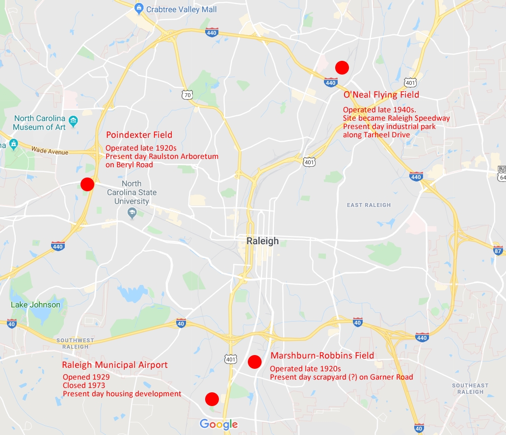
See old Raleigh airfields mapped at
https://www.google.com/maps/d/u/0/embed?mid=1OGGmwHP-q1NsP55t_d5cHvPjpsUacNF8
Research materials available for download at
https://drive.google.com/open?id=1WtIW0IaNUTT3HtpjKjqGXyUrTz27bmMP
Acknowledgements. This research was assisted by Mark Turner, Brandon Taylor,
Brandon Hopkins, Jacob Simpson, Bryce Clodfelter Jr., and Kent Rogers.
Contents
- Chamber of Commerce field
- Marshburn-Robbins Airport
- Poindexter Airport
- Curtiss-Wright Field / Raleigh Municipal Airport
- O'Neal Flying Field
- Lake Woodard landing strip
- Wake Forest Airport
Airfields
Chamber of Commerce field - Raleigh
Opened 1920?
Closed TBD
East of city on New Bern Avenue
First permanent airfield in Raleigh, after temporary landing fields
at such locations as the Raleigh Country Club and at a site on New Bern
Avenue. In 1920, the Raleigh Chamber of Commerce started a project to
establish a permanent field, and the field on "old" Poole Road (New Bern
Avenue) was chosen, and they renewed their lease. A hangar was donated,
a huge "T" of white clothed marked the site, and the famous "Flying Parson" Belvin Maynard was one of the first
planes to land on April 7, 1920. The airfield was called the "municipal
field" though it received no city funds.
Location TBD, with references including:
- Two miles east of city
- Three miles east of city
- One mile SE
See map showing eastern edge of city limits in 1920:
legeros.com/ralwake/raleigh/history/timelines/1920-1929.shtml
Described in 1921 as flying guide:
- Municipal field
- One mile SE
- 1200 x 150 feet
- Half-mile from ball park
- "T" mark for identification
News and Observer stories:
- Nov 2, 1919, "'Flying Parson' Sets Foot Upon Native Heath For
First Time Since Cross-Continent Flight"
- Apr 7, 1920, "Flying Parson Will Arrive Here Today"
- Apr 8, 1920, "'The Flying Parson' Smiles His [...] Landing on
Raleigh's New Landing Field"
- Apr 8, 1920, "'Flying Parson' Preaches Sermon"
- Oct 4, 1920, "Avro Beats Canuck Without Difficulty"
Sources:
- Flying Guide and Log Book by Bruce Eytinge - John Wiley & Sons -
New York - 1921 - Via Google Books
- Wake - Capital County of North Carolina - Volume II -
Reconstruction to 1920 - By K. Todd Johnson and Elizabeth Reid
Murray
Marshburn-Robbins Airport - Raleigh
Opened 1927, by
Closed 1929
2300 block of Garner Road, best
guess. Present site of a scrap metal yard.
Notes:
- Listed as operational municipal airport in federal Airway
Bulletin No. 237, Nov. 10, 1927
- First day of operation on January 15, 1928, as reported in next
day's News and Observer
- Listed as no longer operational as of September 30, 1929, in
federal Air Commerce Bulletin, Vol. 1, No. 12, December 16, 1929
Described in 1927 airway bulletin:
- Location of Lat. 35° 37', Long. 78° 40'.
- No runways, no lighting, no facilities
- Operated by Alton Stewart, with land leased by City of Raleigh
Sources:
- Air Commerce Bulletin, No. 237, Nov. 10, 1927
- Air Commerce Bulletin, Vol. 1, No. 12, Dec. 16, 1929 - Via Google
Books
- News and Observer, July 21, 1928, "New Signs Pointing Way to
Marshburn-Robbins Airport"
- USDA Historical Aerial Photos,
https://guides.lib.unc.edu/aerials
Poindexter Airport - Raleigh
Opened 1927
Closed 1929
4400 block of Beryl Road, best
guess. Present site of Raulston Arboretum.
Notes:
- Lease recorded by county clerk on March 5, 1929, from Berry
O'Kelly and wife, to H. B. Poindexter, for five years, from January
1928, to December 31, 1932. Book-Page: 000567-00237
- Listed as operational commercial airport in federal Airway
Bulletin, No. 313, March 13, 1928
- Described as a "new" airfield in News and Observer story on January 16,
1928, with work still underway, and a formal opening planned in the
spring. Originally named Carolina Field until January 1928. Head of the
"enterprise" was H. B. Poindexter, Army Reserve Pilot
- Site of city's first fatal airplane crash on January 11, 1929.
The Travelair plane crashed after take-off at 3:30 p.m.
- Listed as no longer operational as of September 30, 1929, in
federal Air Commerce Bulletin, Vol. 1, No. 12, December 16, 1929
- Recalled in News and Observer retrospective on August 25, 1938, as
"what some residents may recall as Poindexter Field--across from the
State Prison Farm at Method"
Described in 1928 airway bulletin:
- Location of Lat. 48° 35', Long. 78° 40'
- 60-acre site, 1500 x 1800 feet
- Four runways of 1700, 1500, 1000, and 1000 feet
- No lighting, one hangar, with "space for two ships"
News and Observer stories:
- January 16, 1928, "War Smoulders: Aviators Busy - Crowd Gathers
at Garner Road Field But There is No Outbreak of Hostilities"
- January 12, 1929, "First Airplane Fatality Here" / "Greenville
Man Killed in Airplane Crash here - C. H. Dodson, Victim of First
Air Fatality in History of Raleigh"
- August 25, 1938, Editorial column, "Frank Hawks by Charles J.
Parker"
Other Sources:
- Air Commerce Bulletin, No. 313, March 13, 1928
- Air Commerce Bulletin, Vol. 1, No. 12, Dec. 16, 1929 - Via Google
Books
- USDA Historical Aerial Photos,
https://guides.lib.unc.edu/aerials
- Wake County Register of Deeds
Curtiss-Wright Field
Raleigh Municipal Airport
Opened 1929
Closed 1972
NW of intersection of Tryon Road
and US 70/401. Present site of residential neighborhood.
- Originally named Curtiss-Wright Field
- In 1932, Eastern Air Transport started airmail and passenger
flights
- In 1933, described as 300-acre field of clay and sand, with five
runways, the longest of 3,200 feet. With a single hangar with
"Raleigh" painted on the top
- Later named Raleigh Municipal Airport
- In 1933, Curtiss Wright Flying Service went bankrupt, and the
city leased the property. Serv-Air subsequently provided airport
services
- In 1934, renovated and re-opened, with all three runways paved,
and lighting added
- In 1940, sold to private owners, after the city of Raleigh
joined a land purchase for a replacement airport for passenger
traffic. The city joined with Durham and purchased 891 acres of land
in 1941, located midway between the two cities, on what would become
Raleigh-Durham Airport
- During World War II, the airport was used for military aircraft
- Also site of several air crashes, over the decades
- In 1972, the airport closed and the property was sold to a
developer with plans for a shopping center and industrial park,
which were never fulfilled
- In 1973, the property was sold to Norfolk Southern railroad, and
the hangar and administration building were demolished
- See below for continued site history
Source:
airfields-freeman.com/NC/Airfields_NC_Raleigh.htm#raleigh
See also
December 29, 1991 retrospective from the News & Observer
O'Neal Flying Field - Raleigh
Opened 1947
Closed 1951, by
Present site of industrial park along Tarheel
Drive.
- Operated by William S. O'Neal Jr.
- O'Neal Flying Service later became the Raleigh Flying Service
- County clerk recorded deed of sale on October 22, 1946
- Dedicated June 1, 1947 as a Civil Air Patrol flight center
- On same day, two people killed in a light plane crash during the
event air show. O'Neal Flying Service sued in 1949 by family of
passenger of plane
- Portion of site sold in 1951 for use as race track, became
Raleigh Speedway
News and Observer stories:
- Sep. 15, 1946, Advertisement, "See Raleigh from the Air"
- Dec 5, 1946, "Airport Battle Goes to Courts - Adjacent Property
Owners File Suit Here to Stop New Airport Project"
- Feb 5, 1947, "Measure Introduced to Regulate Airports in Wake
County - Bill Would Give Power of Zoning - Rep. Hatch Disclaims
Connection But Measure is Believed Aimed at New Field"
- May
19, 1947, "CAP to Dedicate New Local Field"
- Jun 2, 1947, "Air Show Crash Kills Two Here - Two Raleigh
Men Perish In Air Show Crash Here - Big Sunday Crowd at Field
Dedication Sees Young Pilots Fall to Death"
- Nov 2, 1949, "Court Hears Wake Appeals" [lawsuit of crash
victim's widow against O'Neal Flying Service]
- Nov 23, 1952, Legal Notices [description of boundaries of
speedway property]
- Nov 12, 1982, Obituary of William S. O'Neal Jr.
Other sources:
- Wake County Register of Deeds
Lake Woodard landing strip - Raleigh
Opened By 1971
Closed TBD
East-west grass landing strip
behind 3200 block of Lake Woodard Road.
At least one air crash associated with the landing strip, on July 28,
1973. Single-engine plane crashed near Melrose Drive after failing to
clear the trees upon take-off. The four occupants were not injured. Two
fire trucks from New Hope FD responded.
Notes:
- Not seen in 1959 aerial photo
- Seen in 1971 aerial photo
Sources:
Wake Forest Airport
Opened 1969
Closed TBD
1500 block North White Street
Opened June 22, 1969, with an open house. Created by "airplane hobbyist"
Frank Swett Jr. Located on North White Street [named Old Wake
Forest-Youngsville Road, at the time], one mile north of town.
Had 2,200-foot unpaved runway perpendicular to roadway, that straddled
(exactly?) the Wake-Franklin county line. [Alt. measurements of 2,200 by
75-foot airport site.] Features initially included
prefabricated building for office and pilot's lounge, tie-down
facilities, and runway lights. It could accommodate 15 to 20 aircraft,
at the time of opening.
Sources:
- News and Observer, June 22, 1969
- Wake Weekly, undated articles in 1968 and 1969
- USDA Historical Aerial Photo from 1971, annotated by Kent Rogers
Forthcoming
- Hendricks Airport - Zebulon
- Buchanan Field - Lizard Lick
- Raleigh Heliport
Map
Copyright 2025 by Michael J. Legeros